Stockton Dives into Prohibition History with National Geographic
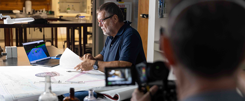
Stephen Nagiewicz, a marine archaeologist, diver and adjunct instructor of Marine Science, looks at shipwrecks on a map at the Marine Field Station during a film shoot for an episode of National Geographic's Drain the Oceans.
Galloway, N.J. -Stephen Nagiewicz, an adjunct instructor of Marine Science at Stockton University, tucked a sketch of a shipwreck between the pages of a logbook for safe keeping. He knew the amber flasks poking up like gravestones on the seafloor were all that remained of a story worth telling, but how the details would be uncovered was still a mystery.
Thirty-five years later, he got a phone call that would end up deploying multibeam sonar, an ROV, divers, a film crew with cameras in the air and sea, and computer-generated imagery (CGI) to reconstruct the ship and its secret role in prohibition for a season 6 episode of National Geographic’s docuseries “Drain the Oceans.”
Mallinson Sadler Productions, based in England and Scotland, was looking for marine archaeology experts who could take them to a shipwreck with ties to illegal smuggling of alcohol. James Delgado, a maritime archaeologist known for his investigations of the Titanic, Monitor, Arizona, Conestoga and more than 100 other wrecks, pointed them in the direction of Atlantic City and gave them his colleague Nagiewicz’s name.

In the 1990s, Nagiewicz, who was running a scuba diving charter company at the time, wanted to look for new spots to explore. He’d been given GPS coordinates from a friend who was the captain of a fishing charter boat. The wreck had been fished, but because it’s so small and hard to find, his friend suspected it had never been seen by divers.
Nagiewicz decided to go and have his own look. He and his wife, Barbara, who were the first to explore the wreck, found much more than they could have imagined.
A Bar’s Worth of Whiskey in One Dive
The coordinates took Nagiewicz and his crew 25 miles off the coast of New Jersey into the New York Bight. Traveling at 8 knots, the commute took over three hours.
“When we got to the location, we couldn’t find it. It took me the better part of an hour to drive around and find some kind of rise on the seafloor that would indicate there’s a wreck. Then all of a sudden it just popped up. Maybe it was 6 feet tall, with a lot of low-lying wreckage that we saw on the sonar,” he recalled.
They anchored into the wreck and descended about 130 feet; a depth unreachable to the sun.
“As we got closer to the bottom, our eyes acclimated to the lack of light, so we started to see the surrounding wreck site. The first thing we really saw was the engine sticking up,” he said.
A single-piston steam engine, a thick propeller shaft and a propeller blade with lots of surface area all rested less than 30 feet apart, suggestive of a small, but powerful boat.
“We looked at each other and said this looks like it would be a tugboat,” said Nagiewicz.
There were bricks scattered on the seafloor like puzzle pieces dumped out of their box. “They would have surrounded the boiler to keep the temperature down as they created steam for the engine,” he explained.
The meaty planks of the wooden hull had deteriorated leaving the bare framework protruding from the sandy bottom like a skeletal ribcage.
The divers fanned their hands over the seafloor to create a current to disperse sand in the hopes of uncovering shallow clues to the tug’s past.
“We started to see cases with numbers of bottles—the necks popping up out of the sand. They must have been very close to the surface. There’d be 1, 2, 6, 10, 12. The lead seal was on top. They were all intact. They were full,” he said.

Nagiewicz still remembers the sound of their giddy laughs muffled by the regulators as they marveled at the discovery.
“They were amber flask bottles—it could only be whiskey or rum or some kind of alcohol. We pulled them out of the sand one by one, and you could see the liquid swishing around,” he said.
Then their thoughts quickly drifted to, “what were whiskey bottles doing here 25 miles offshore?”
They never expected to find whiskey bottles, and certainly not on a tugboat that sunk well beyond the range it would typically be working. “This has got to be something more than just a tugboat. What’s it doing out here and why is it carrying cases and cases of bottles,” he wondered.
They had mesh bags in the event they caught a lobster on the wreck, but on this dive, they filled up with whiskey bottles.
“Being curious and adventurous, probably a little crazy, we opened one up and tasted it. It was either really bad whiskey or salt water had intruded into the bottles over the last 80 years,” he said.
After a sip of prohibition, Nagiewicz’s imagination began to think about the crew, their fates, and their families. The crew aboard never made it back to their loved ones.
“If this wreck is indeed as old as we thought, early 1900s, lifesaving wasn’t that easy 25 miles offshore. I’m willing to bet no one knew this tug was 25 miles offshore whether it was blown there by a storm or sunk by accident or intentionally,” said Nagiewicz.
What started as a fun dive “turned into a search for history” that would span decades.
One phone call would speed up that process using advanced technology, old-fashioned research and connecting key researchers.
The Return with Multibeam Sonar
In the years following Nagiewicz’s dive, he found little research being done on local wrecks, and he struggled to find a record of the tugboat he dove.
“If the wreck wasn’t reported missing, there is no record of it. Back then, if they didn’t tell anybody, no one knew where they were. You have to remember while everyone was running illegal booze, it was still illegal to do so. Most of the wrecks we will never know what they were. There is nothing on the bottom to name them,” Nagiewicz said.
Many visits to maritime museums were like searching for a needle in a haystack.
“The New York City Harbor records are in archives at the South Street Seaport Museum, and it would take a researcher month to go through the records to find any departure plans. We thought, well if we were carrying illegal alcohol, we wouldn’t file a departure plan either, which would make the search harder,” he said.
When the tugboat caught the attention of National Geographic, an effort began to drain the ocean surrounding the shipwreck with CGI technology to resurface the secrets of prohibition’s past.

In July of 2022, Nagiewicz would revisit the wreck to create a 3D model with multibeam sonar aboard the Stockton Marine Field Station’s R/V Petrel with Peter Straub, a professor of Biology, and a diver, Steve Evert, director of the Stockton Marine Field Station and captain of the R/V Petrel, sonar experts and a film crew from Mallinson Sadler Productions.
The break in the weather finally came six days into a two-week window, and with the two GPS points that Nagiewicz had recorded on his sketch of the tugboat, the crew set off on a six-hour ride, the Petrel’s longest expedition to date.
Steve Evert, director of the Marine Field Station, started watching “Drain the Oceans” after surfing channels one night. His wife is a history teacher and he works to support Stockton’s marine science and biology research, so the show was an intriguing combination of their shared interests.
He never imagined he’d be driving a crew to map a shipwreck on the R/V Petrel for an episode.
His role as the captain was to run the lines from the survey team to get the acoustic data to hit the target.
When the crew arrived at the GPS coordinates, they began looking for the wreck with the sonar.
After hours of searching and phone calls to confirm coordinate numbers, the wreck never appeared on the computer screen.
The tugboat surrounded by cases of smuggled whiskey bottles that Nagiewicz swam, sketched and even sipped was no longer visible.
The rum runner had bamboozled the Stockton crew
The Ocean Covers Up Evidence of Smuggling
Straub understands the power of the ocean’s currents, which likely played a part in hiding history.
“Looking at the data that we collected, a rather wide swath, it looks like a pretty active area. There are some sand ridges to the east which look like they may have been migrating in. If you look at the Sahara Desert and the pyramids, there was a period of time when they were covered by roving sand dunes and then uncovered again. That happens on the seafloor as well. They move due to things like hurricanes and we’re in hurricane alley here. That area probably saw a lot of changes due to Hurricane Sandy and Irene, which moved large amounts of sand, not only on the beach but the shallow water as well,” Straub explained.
Evert noted that metal can persist, but wood underwater will not last. The combination of geologic forces and degradation over time are likely to blame.
“Sand doesn’t stay in one place, it could be unburied in a year,” Evert added.
Further up the coast, another piece of the story was resting on the seafloor 8 miles offshore of Rockaway Inlet.
A Sister’s Plea to the NY District Attorney’s Office Reveals a Sister Tug
Nagiewicz was reading a book “Smugglers, Bootleggers and Scofflaws. Prohibition and New York City.” written by historian Ellen NicKenzie Lawson when he came across the transcript of a letter from Agnes McCardle to the assistant district attorney for New York.
She wrote about her brother who worked on a tugboat, the William P. Malone, which disappeared along with its crew of 13, one of them her brother. The captain and owner had a poor record of maintaining his ships.
“The captain had another ship, the Lizzy D, that two years earlier sank probably from that same lack of maintenance. The Lizzy D was the only prohibition tugboat that any of us knew about at that time that we could scuba dive. It was found in 1977 by a couple of dive boat captains,” Nagiewicz said.

That letter was the missing puzzle piece connecting two nearby tugboats that sunk while transporting alcohol.
“This letter kind of tells us that the wreck we were on—we already knew it was a tugboat and carried whiskey bottles—was a rum runner too,” he said.
Nagiewicz and his wife had very likely dove to the William P. Malone, a sister ship to the Lizzy D.
“We are 90 percent certain it is the William P. Malone. I can never be 100 percent sure until we can identify the name of the ship or some kind of striking feature that only William P. Malone had,” he said.
The letter also shared that there was an SOS sent out looking for the ship and 11 days after it sank, the Coast Guard was still looking for it on the tip of Long Island.
With the William P. Malone buried and deteriorating, the next best move for the "Drain the Oceans" episode would be to visit the Lizzy D.
Mapping a Sister Tug
The Lizzy D was a rum running tugboat that went down in 1922 in the approaches to New York Harbor just southeast of Long Island, a place the R/V Petrel had never been.
Evert typically takes students and faculty to inlets for mapping and to marshes and beaches to study local ecosystems and beach processes.
“Outside New York Harbor is an area that we don’t operate in a lot because it’s in the shipping lanes to New York City. We were pivoting around freighters coming in with giant containers stacked on deck,” recalled Straub.
Evert remembers seeing dozens of freighters anchored waiting their turn to enter the harbor.
When they reached the coordinates for the Lizzy D, the weather and wind died down.
“We setup a reconnaissance line over the most likely points and started to run down the line. Up popped something. It’s just a small bit of relief on the bottom, but your heart jumps. A couple seconds later a much larger piece of relief came into sight, which turned out to be the boiler,” said Straub.
The rest of the day was spent drawing an image of the Lizzy D by boat.

The Petrel’s movement mimicked the pattern of a lawn mover’s overlapping parallel lines. Evert described the acoustic sonar signals as acting like a beam from a flashlight. To get a detailed picture or look at the wreck, the beam needs to hit the wreck from multiple angles.
After drawing parallel lines, Evert started a new series of perpendicular lines and then more at 45 degrees.
The multibeam sonar was obtained with a grant ($300,000) from the National Science Foundation. A 3D model can be built with the point-cloud data collected from the multibeam sonar, which makes the wreck accessible to the public.
“We were able to use the images to develop a picture of what it looked like, but we couldn’t get the exact detail. For that we needed to dive. We put the ROV in and divers in the water. One of the key things we saw on the stern was a large tow bed, which indicated that the primary purpose of this ship was as a tow vehicle,” said Straub.
The "Drain the Oceans" episode, as its name suggests, digitally empties the Atlantic Ocean to reveal a graphic recreation of the Lizzy D.
A Field That Merges History and Science in a Marine Environment
“One of the allures of shipwreck diving is the history,” said Nagiewicz.
Marine Science is a field that can use sonar or remote sensing technology and an understanding of oceanography to access underwater history. The storytelling process is one that takes researchers from the ocean to the archives.
And in some cases, the story makes its way onto TV screens for the world to watch.
Watch the trailer.
Listen to a podcast featuring Nagiewicz talking about the episode and other local shipwrecks.
Go behind the scenes on the day of the filming at the Marine Field Station on Flickr.
Story and photos by Susan Allen

