Galloway - Main Campus, Engineering Study
Land Use Zoning
Zoning is the legislative method of controlling land use by regulating such considerations as the type of buildings (e.g., commercial or residential) that may be erected and the population density. It is accomplished by dividing land area into zoning districts, each having specific conditions under which land and buildings may be legally developed and used. In combination with other planning techniques, zoning is a major instrument for gaining greater physical order in the built environment.
Zoning Evolution
Richard Stockton College of New Jersey (Stockton) opened its main campus in Galloway Township in 1971, prior to the adoption of the New Jersey Pinelands Protection Act. When the Act was adopted in 1979, the New Jersey Pinelands Commission was formed and delegated the responsibility for the implementation of the Pinelands Comprehensive Management Plan (CMP) which provided the standards, rules and regulations to guide development within the Pinelands Protection Area in accordance with growth management areas that were adopted as part of that plan.
At the time of the adoption of the CMP in 1979, the entire Stockton campus within Galloway Township was zoned as Rural Development (RD). At that time, the designation of the Stockton campus as an RD zone did not pose a problem to future growth because public sewage infrastructure was in place within the campus and the rules and regulations of the CMP did not have limitations for projects that had direct access to sewage utility infrastructure.
In 1990, the standards of the CMP, that pertain to facilities within the RD zone and were to be served by public sewage collection and treatment system, were significantly revised. This change to the CMP severely restricted future expansion of the campus. In recognition of this hardship, the Pinelands Commission supported Stockton via Galloway Township to apply for a rezoning of the campus in accordance with the 1990 Master Plan. As a result of this effort, the Regional Growth (RG) areas around the core of the Stockton campus were established. As part of the process, the wetlands that were adjacent to the core area of the Stockton campus were delineated and verified by the New Jersey Pinelands Commission. Wetlands buffers within the core areas were reduced to 175 feet, based on the Wetland Reduction Buffer Model.
In 2005, it became apparent to Stockton that to meet the growth projections over the next ten years, the campus would have to expand beyond the core areas. Stockton had been engagedin an ongoing dialogue with the Pinelands Commission to rezone portions of the RD area to become RG. Stockton also determined that it would be prudent to utilize a global and holistic approach to the future development within its campus. Until the development of this current plan, each project was done as an individual standalone project; not part of a greater whole. This meant each project had its own topographic survey, wetlands delineation, threatened and endangered species survey, and stormwater management study.
Stockton, and its consultants, performed lengthy and detailed studies related to wetland delineations and threatened and endangered species, each to identify and evaluate the environmentally sensitive areas of Stockton-owned land. While these environmental studies were being performed, the Pinelands Commission undertook a reevaluation of the entire Pinelands Protection Area, based on an Ecological Integrity Assessment (EIA) model that sought to zone areas of the Pinelands based on their EIA index. We were informed by the Pinelands Commission that portions of the Stockton campus to the east of the core areas had a high index and the Pinelands Commission desired to downzone this area from Rural Development to Forest. For the portion of the Stockton campus south and west of the core areas, the index was not as high and warranted a change to Regional Growth. Due to several reasons, the change of zoning through the EIA model at Stockton was not approved by the Policy and Implementation Committee of the Pinelands Commission. Stockton was then advised to pursue a traditional rezoning of the campus by having Galloway Township as the lead entity for requesting the rezoning. Although the zoning change was not approved by the P&I Committee, Stockton was willing to put forth a good faith plan for sensitive threatened and endangered species areas and do so by supporting the original desires of the Pinelands Commission to preserve and deed restrict that particular area of interest.
The rezoning of the Stockton campus was generally, for 472 acres of the Stockton property previously zoned RD fronting Jimmie Leeds Road, Duerer Street and Pomona Road. Areas south of the Academic Core Area were rezoned as RG, and the remaining 583 acres of the main Stockton campus, along with 227 acres of offsite parcels north of the main campus (for a total of 810 acres) were deed restricted to preserve the land in perpetuity. The 810 acres of land deed restricted contains the forested area the Pinelands EIA originally proposed as Forest Management Area and effectively creates greater protection for the land than rezoning would have. The area of the Stockton campus rezoned RG contains the same areas that the Pinelands EIA originally proposed as RG, with the environmentally sensitive areas within the proposed RG zone to be protected from development due to Pinelands CMP standards for wetlands, buffers and threatened and endangered species critical habitat.
Current Zoning
The current zoning of the Stockton Galloway Campus , generally for 991 acres of the Stockton property fronting Jimmie Leeds Road, Duerer Street and Pomona Road south of the Academic Core Area, is Regional Growth (RG). The remaining 583 acres of the main Stockton campus, along with 227 acres of offsite parcels north of the main campus (for a total of 810 acres) is identified as Restricted Development (RD), and deed restricted to preserve the land in perpetuity. The 810 acres of deed restricted land contains the forested area the Pinelands Ecological Integrity Assessment (EIA) originally proposed as Forest Management Area and effectively creates greater protection for the land.
Development Area Evolution
The 2010 Master Plan identified ten (10) primary development areas on campus with several infrastructure improvements on and off campus. These areas were broken down by way of functional need and to a degree geographic location. The itemization of each area included as much information as was available for the functional need for the space to be developed.
In the current 2020 Master Plan Update, the 10 previously identified areas were reduced to eight (8) core concepts on the Galloway Campus and the inclusion of Stockton Atlantic City, Kramer Hall in Hammonton, the Port Republic Marine Field Station, Manahawkin Center, The Sam Azeez Museum of Woodbine Heritage in Woodbine, and all other individual properties owned throughout the region.
The University’s development plan has evolved through the vetting process of the Stockton Space Management Committee, President’s Cabinet, Building and Grounds Subcommittee of the Board of Trustees, Athletic Facility Taskforce, and the yearly Capital Budget submitted to the State for approval.
Overall Campus Master Plan
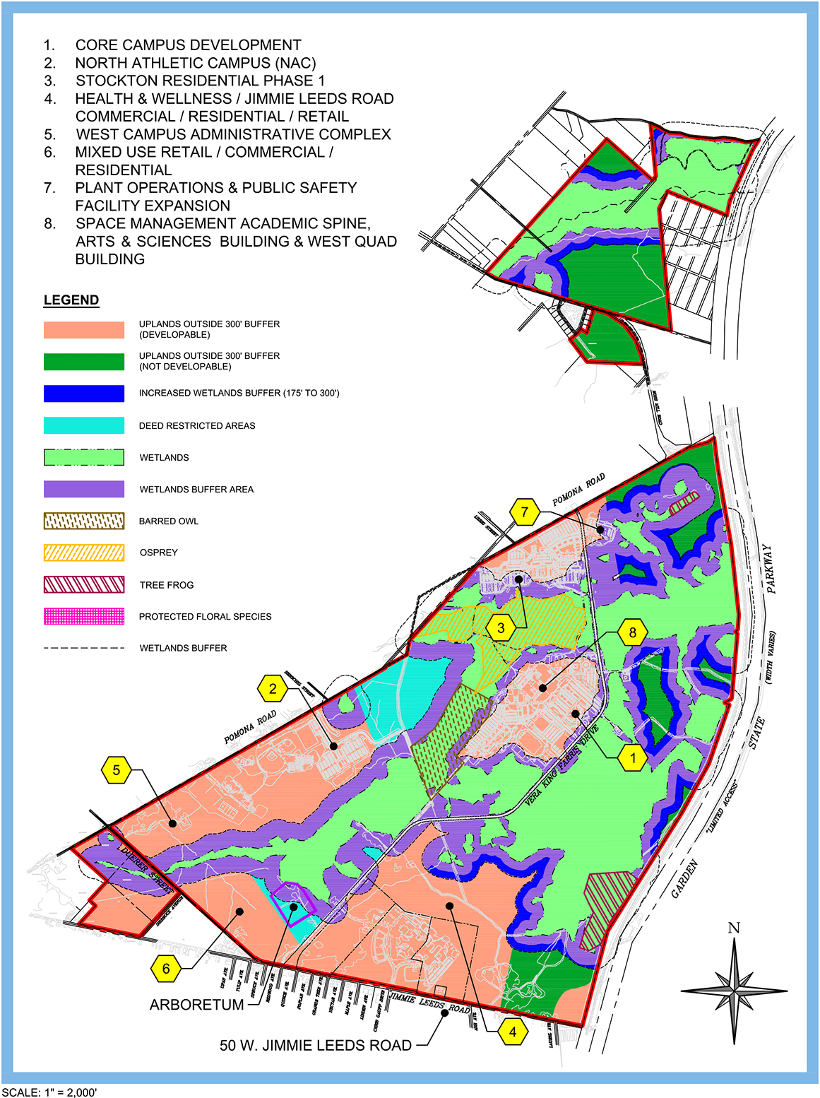
The Overall Campus Master Plan depicts an assemblage of all planned facility development located in areas that do not impede on environmentally sensitive habitat. Each intended development is identified, and a detailed breakdown of the proposed use of each development is provided in a following section. It is important to establish a clear understanding between the University and the community at large as to our planned development activity, so that we all can take the necessary steps to protect and defend the balance of the environment from a haphazard and reactionary development process. The plan also identifies all threatened and endangered species types that we have found as a result of environmental testing by Marathon Engineers.
In addition, the plan identifies lines of demarcation for wetlands and wetlands buffer areas that have been historically established. Within this updated plan, we have identified areas of land that we intend on preserving (due to our findings by way of study) that are within an “uplands” type of designation, as well as having identified areas of uplands that have been deed restricted from any future development.
Deed Restricted Areas
Stockton University has identified 914 acres of the Galloway Campus to be deed restricted. It is intended that the only disturbance that will be allowed within this area will be associated with Forestry Stewardship Management and Environmental Studies, along with the existing utility and service infrastructure in the area that will remain unaltered.
Preservation Areas
In order to achieve an environmentally-balanced approach to the implementation of this Master Plan Update, Stockton has intentionally purchased large land masses for the purpose of future preservation in order to lessen the overall environmental impact while additional facilities are proposed and planned to meet the increase in projected enrollment.
The property that was purchased by Stockton for the purpose of preservation includes 227 acres that are adjacent to the Garden State Parkway and 51 acres that are adjacent to the southwest corner of its core Galloway Campus. All these areas are a combination of forest and wetlands. Of this total acreage, Stockton has preserved/deed restricted all but 20 acres, a small area that will be used to support a portion of Development Area 6 (Mixed-use Retail/ Commercial/Residential) adjacent to Duerer Street.
Wetlands Delineation
To create greater efficiencies in land utilization at Stockton, an initiative was undertaken to perform a comprehensive environmental and engineering evaluation of the entire Stockton campus. All the wetlands within the Stockton campus were delineated by Marathon and verified by the Pinelands Commission thereby eliminating the need to perform individual delineations for each project moving forward.
- Wetlands act as filters or sponges because they absorb and remove pollutants from the water that flows through them. Therefore, wetlands improve the water quality of lakes, rivers, and reservoirs downstream.
- Wetlands control flooding by absorbing extra water when rivers overflow, which protects farms and urban and residential areas from damage.
- Buffering shorelines against erosion.
- Providing spawning grounds and habitats for commercially important fish and shellfish.
- Providing habitat for rare, threatened, and endangered plants and animals.
- Providing recreational areas for activities such as fishing, bird watching, hiking, canoeing, photography, and painting.
- Provide a home for native and migratory wildlife.
- Wetlands vegetation traps carbon that would otherwise be released as carbon dioxide, which may be linked to rising atmospheric temperatures.
- Some wetlands are used to provide many commercially important products, such as cranberries.
Following the completion of the wetland’s evaluation, this masterplan process established the appropriate wetland buffers to be maintained throughout the campus. Wetlands buffers in the central core development area were agreed to be established at 175 feet. Outside the core areas, many, if not most, areas are more environmentally sensitive and will require a larger buffer area. With this consideration, Stockton has agreed to use a 300 feet buffer in all areas outside of the core, and so the various maps show the extent of additional land between 175 feet and 300 feet protected by this decision.
Sensitive Areas
Marathon Engineers conducted a comprehensive threatened and endangered species survey of the entire Stockton campus. This study encompassed field work, data collection and management, and reporting for a threatened and endangered species habitat suitability assessment and Phase II (presence/absence) survey for threatened and endangered species. The target wildlife species include Cooper’s hawk, red-shouldered hawk, bald eagle, red-headed woodpecker, barred owl, eastern tiger salamander, eastern mud salamander, Pine Barrens treefrog, southern gray treefrog, timber rattlesnake, corn snake, and northern pine snake. The evaluation identified Barred Owl, Pine Barren’s Treefrog, Eagle Osprey and Pine Barren Gentians within the Stockton campus. Cooper’s Hawk was removed from this Master Plan Update as it is no longer on the Threatened and Endangered Species List. The results of the wildlife and plant surveys will be submitted to the New Jersey Pinelands Commission for review and acknowledgment.
Barred Owl
Barred Owls are brown to gray overall with dark striping on the underside contrasted immediately above that with similarly-dark and tight barring about their throat and nape. Barred Owls are largely native to eastern North America but have expanded their range to the west coast of North America, where they are considered invasive. Mature forests are their preferred habitat, but they are also able to acclimate to various gradients of open woodlands. Their diet consists mainly of small mammals, but this species is an opportunistic predator and is known to prey upon other small vertebrates such as birds, reptiles, and amphibians as well as a variety of invertebrates. Barred Owls are typical for a member of the genera in terms of their nesting habits, tending to raise a relatively small brood often in a tree hollow or snag (but sometimes also in other nesting sites) deep in the woods.
Pine Barrens Treefrog
The Pine Barrens Treefrog is a species of New World tree frog. It is becoming rare due to habitat loss. The Pine Barrens treefrog is named for the New Jersey Pine Barrens. It is a medium-sized green treefrog with a white-bordered lavender stripe down each side of its body and brilliant orange of the underside of each leg. Pine Barrens Treefrogs are found in the pine forests and sandhills of south-central North Carolina.
Osprey
A very distinctive fish-hawk formerly classified with other hawks but now placed in a separate family of its own. Along coastlines, lakes, and rivers almost worldwide, the Osprey is often seen flying over the water, hovering, and then plunging feet-first to catch fish in its talons. After a successful strike, the bird rises heavily from the water and flies away, carrying the fish headforward with its feet.
Pine Barrens Gentians
Of all the Garden State’s native wildflowers, few are more exciting in the fall than the deep blue Pine Barrens Gentians. Gentians bloom from September through early November, a time when most other wildflowers have long turned to seed. Originally discovered by American naturalist William Bartram, Pine Barrens Gentians are a perennial herb which thrive in consistently moist, nutriment poor acidic soils. Listed as a Species of Special Concern by the New Jersey Department of Environmental Protection, their habitats are also protected by the New Jersey Pinelands Commission Comprehensive Management Plan.
Uplands
Upland and lowland are portions of plain that are conditionally categorized by their elevation above the sea level. Lowlands are usually no higher than 200 m (660 ft), while uplands are somewhere around 200 m (660 ft) to 500 m (1,600 ft).
Upland soils are mostly shallow, stony, or gravelly, dark alkaline clays and clay loams underlain by limestone. Lighter-colored soils are on steep side slopes and deep, less-stony soils are in the valleys. Bottomland soils are mostly deep, dark-gray or brown, alkaline loams and clays.
Upland forests occur where drainage is sufficient so that soils do not become saturated for extended periods of time. Water can either run off or percolate through the soil. The upper canopy is 80% to 100% closed, and sub-canopies of younger trees and shrubs typically exist.

