New Jersey Geologic History
 New Jersey Coastal Composition
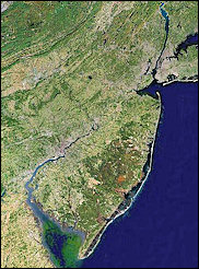
The New Jersey Atlantic Ocean coastline is roughly 130 miles in length and can be classified into three different shoreline types depending on the purpose of the classification scheme (Figure 1). The New Jersey upland along the coast is composed of gravel, sand and silt deposits whose geological origins are derived from both marine and non-marine sedimentary episodes. None of the sediments exposed at the surface in Monmouth, Ocean, Atlantic or Cape May Counties are cemented to form bedrock like that found along the New England coast. Since the geologic layers are not lithified, they erode easily under marine processes like wave action or tidal currents. These sediments are the source of all modern New Jersey beaches by erosion or by the reworking of other deposits formed from these older sediments prior to the present sea level rise. The rise in global sea level has been transpiring for the past 20,000 years at a variable rate, following the melting of the last great ice sheet covering northern North America. The local change has been in the range of 350 feet to 400 feet vertically, which has produced a long-term westward migration of the shoreline. The "New Jersey" shoreline lay at the edge of the continental shelf 20,000 years ago, 80 to 90 miles to the east of the present coast. As the ice sheets melted and retreated into Canada, the ocean marched across the relatively flat continental shelf constantly changing the position and configuration of the New Jersey shoreline. A review of property records from the 17th Century in Monmouth County has demonstrated up to 2,000 feet of shoreline retreat since about 1650. Concerns about surveying accuracy were answered by reviewing property records from the same era, inland near Colts Neck, NJ. Comparative calculations resulted in less than 50 feet of difference in dimensions of large land parcels originally surveyed in the Seventeenth Century. Lands mentioned in 17th Century records are now ocean, having vanished as the ocean continued its march westward in position and upward in elevation. The pattern followed stream channels back up the valley, flooding low areas first allowing the growth of white cedar trees, then salt marsh grass as tide water reached any particular point. Cores of the seafloor penetrate thin layers of beach sand and then enter dark brown salt marsh deposits that cover cedar peat deposits that can be found only a few hundred feet off the beach opposite the location of fresh water lakes present along the Monmouth County coastline.
The ancient coastal plain sediments are directly exposed to wave erosion from Long
Branch, south to Bay Head. This part of the coast has been termed the headlands by
Fisher (1965) and by Nordstrom, et al (1977). Along this stretch, the modern beach
lies directly in front of a bluff that rises from several feet to 26 feet high. The
exposed bluff was often buried by dune sand that blew up over the bluff a short distance
inland. Excavations along the bluff margin in Deal show a contact between clean, well-sorted
sand from dunes lying over the mixed silts and sands of the older deposits comprising
the bluff. Major storms eroded the beach/dune cover and cut into the bluff sediments.
The "new" gravel, sand, and silt were sorted by the waves with the sand extracted
to supply the beaches. Thus as the bluff retreated, the beach out in front remained
well supplied with sand.
The littoral movement of sand distributed it to other segments of the New Jersey shoreline.
This created the modern barrier beaches presently existing between Monmouth Beach
and Sea Bright. North of Sea Bright is Sandy Hook, a feature marking the temporary
end point of sand deposition by littoral processes. Coastal experts refer to these
features as spits. Starting in Long Branch, the spit, which is attached to the mainland
bluff, extended north across the mouths of the Navesink and Shrewsbury Rivers to create
Sandy Hook. Historical records indicate that Sandy Hook has existed at various times
as an island separated from the remaining spit by inlets or was attached to Atlantic
Highlands directly with an inlet just south of Atlantic Highlands into the Navesink
River. Presently, Sandy Hook is at the end of a long peninsula attached to the uplands
at Long Branch. There is little doubt that in the absence of the Sea Bright sea wall,
these large-scale alterations to the configuration of this sand barrier would have
continued to the present.
The Nordstrom classification scheme calls the sediment that moved to the north the
Northern Barrier Spit, and the sediment that moved south the Northern Barrier Islands
Complex (Figure 1). The entire shoreline from Monmouth Beach to the tip of Sandy Hook
is comprised of sand eroded from the Monmouth County bluffs, which was then transported
north by wave-generated littoral currents. The northerly motion is not constant, often
reversing during northeast storms. Long Island acts to shelter the northern NJ coastline
from the full impact of these events, allowing waves approaching from the southeast
to dominate the long-term movement of sand to the north in Monmouth County.
In the last half of the 19th century, the bluff was gradually armored with vertical
walls and later in the 20th century, with a rock revetment to block the erosion of
the cliff and the subsequent loss of upland property. As development expanded toward
and along the edge of the Monmouth County bluffs, property owners eventually demanded
that the retreat of the bluffs be stopped. This armoring process has cut off the re-supply
of sand to the beach and littoral system. The long-term result was that the beaches
diminished in size to almost no dry beach along much of northern Monmouth County and
the Northern Barrier Spit. Massive investments in rock groins and inlet jetties slowed
the process but did not address the real problem, the need for new sand on the beaches.
In the spring of 1994, the United States Army Corps of Engineers (ACOE) New York District started construction on what is the largest beach nourishment project ever attempted in the United States. A 21-mile section of beach, from northern Sea Bright in northern Monmouth County to Manasquan in southern-most Monmouth County, had large quantities of sand placed on the shoreline. This project has proceeded in two sections over a period of 5 to 6 years. At this time, Section I contracts 1A, 1B and 2 are complete and Section II is complete. Monmouth Beach and Sea Bright have had up to 350 cubic yards of sand per foot of beachfront (yds3/ft) placed on the beach, extending the shoreline up to 700 feet seaward of the seawall. During 1997, Manasquan, Sea Girt, Spring Lake and Belmar received sand from borrow sites offshore. Due to limited funding, only Section I, contract 2 for Long Branch was continued and completed in 1998. Section II, contract 1, Manasquan to Shark River was completed October 1997. Section II, contract 2, Asbury Park to Shark River was completed by October 1999. Construction continued during the spring of 2000 as the groins, storm water outfall pipes, etc. were modified or extended. The section of coastline from Loch Arbour north to Lake Takanassee (Contract 3, Deal, 5 million cubic yards) has not yet been nourished. The local sponsor is working on real estate issues and seeking better public access.
In contrast to the northern New Jersey shoreline, the southern New Jersey shoreline
is composed of barrier islands of varying lengths, from 18 miles (Long Beach Island)
to 5 miles (the Wildwoods). Little Beach Island is smaller, but remains undeveloped,
under the jurisdiction of the Edwin B. Forsythe National Wildlife Refuge. The barrier
islands have a very different morphology and depositional history from the beaches
to the north. The sand found on beaches south of Point Pleasant contain progressively
less material derived from the bluffs in Monmouth County (McMaster, 1954). South of
Long Beach Island, the sand is half of the average diameter of that found on beaches
further north and contains a completely different set of trace minerals. This indicates
that this sand supply has either been derived from different sources than that in
Monmouth County or that geologic reworking on the continental shelf has modified the
original sediment prior to its inclusion in the barrier island.
Large lagoonal systems of open bay and salt marsh lie landward of the barrier island
shoreline. The NJ coastal plain comprising the mainland is separated from the beach
and dunes by a half mile to three miles of relatively recent sediments, which begin
in Bay Head, and extend south to Cape May Point, NJ. Tidal inlets divide the barrier
islands from each other. These inlets serve to segment the littoral distribution of
beach sand into cells roughly corresponding to the distance between the individual
inlets. The gentler seaward slope of the southern New Jersey coastal plain has allowed
a wider coastal zone and the inclusion of estuarine regions between the upland edge
and the barrier islands.
Strong tidal currents move sand into and out of the narrow inlet channels between
two barrier islands. As current flow slows down in either the bay behind the barrier
chain, or in the open ocean, the sand is deposited in what are termed flood- or ebb-tidal
deltas (respectively). The more significant of these two features relating to beachfront
changes is the ebb-tidal delta. The delta is essentially a shoal surrounding the inlet
and extending up to several thousand feet along the oceanfront beaches on either side
of each inlet. This shoal produces shallow water seaward of the beach on the adjacent
barrier islands. All waves slow down as they enter shallow water. This, coupled with
the refraction that occurs as the wave reaches the delta, results in substantial alteration
to the wave energy and approach direction to the barrier beach in the immediate vicinity
of the inlet mouth. The delta shoal acts to shield beaches that lie behind the arc
of the shoal from some of the approaching wave energy. Larger waves break first on
the delta margin, losing energy. This combination of effects yields very complex equilibriums,
which vary from year to year and even seasonally. The inter-relationships of wave
energy distribution and beach changes around inlets have only been recognized in the
past 30 years. These relationships are only now being quantified so that management
decisions on inlet navigation dredging and beach nourishment projects can take inlet-beach
dynamics into account.
Six of New Jersey’s eleven inlets are presently confined between rock jetties and
cannot shift position as they once did: Shark River, Manasquan, Barnegat, Absecon,
Townsends, and Cold Springs. Three inlets are still in their natural state with no
structures to modify the natural equilibrium: Beach Haven/Little Egg, Brigantine,
and Corsons. Two inlets, Great Egg and Hereford, have one jetty or one shoreline armored
with rocks to prevent inlet channel migration from taking more of the municipal lands
adjacent to the inlet. A second jetty has been built on the Sea Isle City side of
Townsends Inlet with construction completed July 1999.
Recent scientific studies have shown that the tidal inlets have much greater impact
on beach erosion or accretion (on individual barrier islands) than the steady flow
of littoral currents to the south. If the sand moved south toward Cape May Point in
a never-ceasing stream, then Cape May Point and Cape May City should be buried in
beach sand. The fact is, however, that both of New Jersey’s southern-most communities
were sand starved as major man-made structures and indirect, development-caused changes
contributed to shoreline instability.
The ACOE has completed three beach restoration projects in Cape May County, the first
in Ocean City, the second in Cape May City, and Avalon/Stone Harbor finished in 2002.
These programs are an attempt to restore the balance between sediment transport and
sediment supply. Monitoring of the results will provide quantitative facts on sand
requirements, loss rates, and re-nourishment schedules so that financial planning
can match the demand for coastal beach stability.
The State of New Jersey has completed several moderately sized projects and is concentrating
on cooperative projects with the ACOE to maxi utilization of its shore protection
funding. The Harvey Cedars beach nourishment project on Long Beach Island was completed
during the spring of 1995. The southern third of Ocean City was nourished in the late
summer of 1995, and the City of Brigantine received fill during April of 1997. Brigantine
completed a 638,000 cubic yard maintenance of its 1997 project during the spring of
2001, assisted by FEMA disaster assistance funds from 1998, and NJ State co-sponsorship.
The Absecon Island joint ACOE and NJ State project was completed during the fall of
2003, but limited thus far to the beaches of Atlantic City and Ventnor City. Margate
City and Longport declined to participate in the initial project the ACOE has named
Phase I. During the fall of 2000, the ACOE and the State proceeded with maintenance
nourishment on Ocean City. The plans include adding sand to Strathmere on Ludlam Island
south of Corsons Inlet. It has been 20 years since sand was initially placed on Strathmere
beaches. The Strathmere section was completed as a separate project in the fall of
2001 with 460,000 cubic yards of sand placed along the northern shoreline. Avalon
borough placed 360,000 cubic yards of sand on the northern beaches as a short-term
measure prior to the commencement of the Philadelphia District’s Seven-Mile Island
project in the fall of 2002. Work was completed on the Cape May Point shoreline stabilization
project. Two of that borough’s groin cells received breakwater units as offshore,
submerged breakwaters between existing groins. Beach fill was added to these cells.
The City of Brigantine is scheduled for construction of a federally matched project
originally formulated at the Brigantine Inlet to Great Egg Harbor Inlet Shore Protection
Project. The Brigantine portion was separated from the effort on Absecon Island to
create two projects. The Brigantine project plan focuses on adding sand to the northern
third of the municipal shoreline.
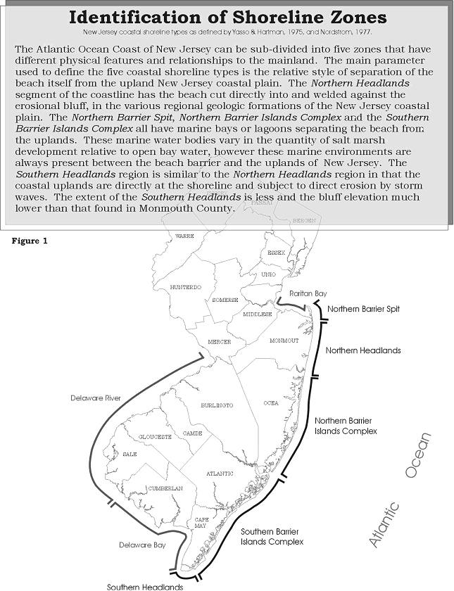 Identification of Shoreline Zones - Click to Enlarge

